MIT-TA expands NYC social equity tool
- March 5, 2024
- William Payne
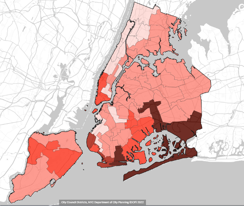
MIT’s Norman B. Leventhal Center for Advanced Urbanism (LCAU) and urban transportation campaign group Transportation Alternatives has launched a new version of their Spatial Equity NYC software. This is a tool that maps and analyses inequities in how public space is used and allocated across New York City.
The expanded tool now includes new data layers, such as flooding or access to public seating, and maps all data by both State Assembly and State Senate Districts for the first time.
Spatial Equity NYC ranks and compares each district by over a dozen equity metrics, so anyone using the tool can see how each community compares to other neighbourhoods across New York City.
Spatial Equity NYC now includes 24 data layers, including six new layers and additional data visualisations. Now anyone can see the percentage of residents who: live in a floodplain, live near a pedestrian plaza, have access to sidewalks, suffer from serious injuries from traffic, and visit the emergency room due to childhood asthma, as well as the average commute times by various modes. The tool also shows every traffic fatality since Vision Zero began in 2014, the canopy of every tree, every on-street city bench, flooding, bus lanes, and subway lines.
An updated Spatial Equity NYC is launching alongside four new fact-sheets on bus commute times for low-income riders; flood risk in Black communities; pollution and traffic violence in the congestion pricing zone; and pedestrian plazas in neighbourhoods of colour. These fact sheets also include recommendations to improve the inequities highlighted in the data.
The tool incorporates raw data provided by trusted sources including the US Census Bureau and the City of New York. Spatial Equity NYC’s update and expansion allows users to analyse data by State Senate and Assembly districts, as well the already-available City Council District and Community Board options.
“Today, we’re expanding Spatial Equity NYC with MIT to give New Yorkers more ways to see how the decisions on our streets impact our health, environment, and infrastructure. The inequities this tool brings to light are staggering, and entirely fixable,” said Danny Harris, Executive Director of Transportation Alternatives. “By empowering New Yorkers with data and solutions, Spatial Equity seeks to build a more equitable, healthy, sustainable, and vibrant New York City.”
“While much of the data we need to advocate for communities exists openly it is hard for policy makers to obtain it, and if they can access it, perform the quantitative analysis that shows how well their community measures up to others. Spatial Equity NYC fills that gap, making it easier to see how well your community is doing, thereby making it much easier to advocate for change,” said Professor Sarah E. Williams, Director of the Leventhal Center for Advanced Urbanism at MIT.