Drone firms partner to map construction sites
- June 7, 2021
- Steve Rogerson
Australian drone data visualisation and analytics firm Propeller Aero is working with Swiss drone company Wingtra to deliver accurate data and 3D mapping to construction and earthworks sites.
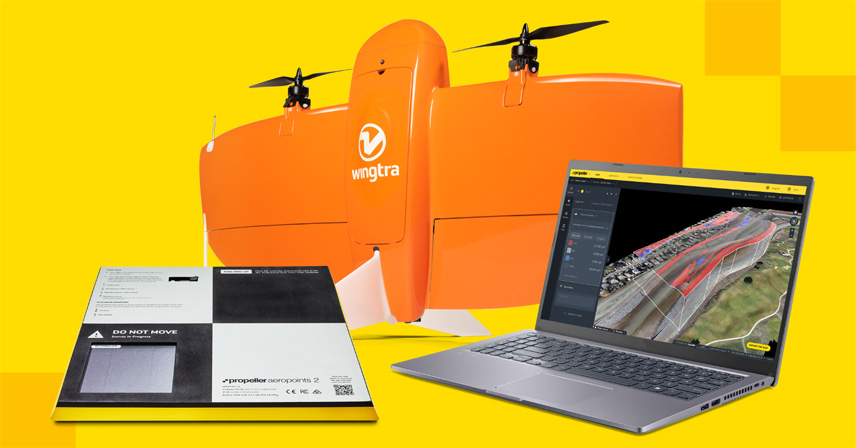
Wingrtra is a vertical take-off and landing (VTOL) drone manufacturer for mapping and surveying.
Designed for the construction and earthworks industry, the Propeller and Wingtra One drone partnership should make it easier for construction professionals to collect survey-grade data across their entire worksite, consistently and accurately. What used to take days or weeks, can now be completed in hours, with more accuracy and reliability.
To operate, surveyors place Propeller AeroPoints (smart ground control points) on their worksite, then fly the Wingtra One drone to collect worksite survey data. Survey images are uploaded to Propeller’s cloud-based platform where the fully automated geotagging and photogrammetry processing is completed within 24 hours of submission on the platform.
“Many Propeller customers are flying massive mines, road and railway projects, and other large sites, and are seeing the value of VTOL drones for their operations,” said Jack Nachazel, customer success engineer at Propeller Aero. “Our partnership with Wingtra meets a significant demand in the industry for more efficient and highly accurate survey data that support not only time and cost savings, but also reliable data you can trust.”
Wingtra One data collection with AeroPoints and Propeller PPK (post processed kinematic) reduces risk and improves efficiency by serving as a reliable, single source for survey data and progress. Unlike traditional survey methods, which require manual, error-prone data collection, surveyors can fly their site on a regular basis to collect and process survey data.
Teams across the entire worksite can view geographically accurate, realistic 3D site models and track, inspect and report on job progress and productivity. This increased accuracy and reliability has been shown to reduce conflict, more quickly resolve disputes and drive more pre-construction bid precision.
“Improving accuracy, reliability and efficiency for survey data is imperative for our customers,” said Julian Surber, product manager at Wingtra. “Partnering with Propeller to provide a complete solution with the Wingtra One drone, AeroPoints and Propeller’s PPK data processing and visualisation is the right step towards better serving our customers.”
Whether at a highway, industrial complex or mine, Propeller and Wingtra enable surveyors to collect and analyse survey-grade data seamlessly to ensure their projects are on track, on budget and on spec.
Propeller’s drone analytics help capture accurate surveys of worksites to measure and track progress and make better and faster decisions around site management.
Headquartered in Switzerland, Wingtra is a VTOL drone producer for surveying, construction and mining industry professionals. Since its market entry in early 2017, Wingtra has partnered with more than 80 of the biggest equipment dealers around the world and has been selling mapping drones globally ever since.