New York pilot helps blind people catch buses
- November 2, 2020
- Steve Rogerson

New York is running a pilot programme that lets blind and low-vision bus riders use their smartphones to find bus stops and learn of arrival times.
The Metropolitan Transportation Authority (MTA) and the Transit Innovation Partnership have launched the pilot with assistance from the New York City Department of Transportation (NYCDoT) along the M23 SBS bus route display decals.
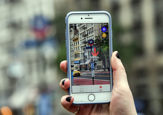
The NaviLens app, which can be downloaded on Android or iOS devices, translates visual signage into audio and helps users determine the accurate location and distance to the nearest bus stop, find out when the next bus will arrive, know how crowded the bus is if the necessary sensor technology is onboard, and be directed onto the bus when it pulls up to the stop.
Colourful, QR-style 18cm-tall codes are installed on bus stop poles that the app can detect from up to 12m away and at an angle of up to 160 degrees. The code does not have to be in focus for app detection and will direct the user by providing audio directional cues including distance and angle to solve the last-few-metres wayfinding problem for the blind in which GPS technology does not guide to a destination’s exact location.
The M23 SBS bus route is popular, carrying almost 14,500 weekday riders pre-pandemic. It is the eighth busiest bus route in Manhattan with stops near the Selis Manor Residence for the Blind, Visions Services for the Blind & Visually Impaired, and Andrew Heiskell Braille & Talking Book Library.
“Accessibility is a key priority for the bus system and MTA family,” said Craig Cipriano, president of MTA Bus, “and this app pilot is another way to help bus riders who rely on audio cues and signals to guide them.”
NaviLens was one of nine start-up companies selected as part of the 2020 Transit Tech Lab, which called for private sector innovations to improve public transit accessibility. The lab is a programme of the Transit Innovation Partnership, a public-private initiative created by the MTA and Partnership for New York City in response to governor Andrew Cuomo’s call for private sector innovation to improve and modernise public transit.
“Bringing new thinking and cool technology to solve stubborn challenges related to accessibility is a very rewarding part of my job,” said Mark Dowd, MTA chief innovation officer. “NaviLens is one example of the many technological advances being made for the accessibility community.”
NaviLens, based in Spain, works to solve the last-few-metres wayfinding problem using code. Detectable from 12 to 45m away depending on the size of the code, NaviLens provides the exact location of a destination and the pertinent visual signage. It has been implemented on Barcelona, Madrid and Murcia transit systems, as well as museums, schools and offices in Europe and the USA.
NaviLens was introduced to NYCT last year as one of the technology features tested at the NYCT Accessible Station Lab at Jay St-MetroTech subway station in downtown Brooklyn. The MTA living lab tested dozens of new features – smartphone apps for wayfinding, floor treatments, braille and tactile maps, digital signage and in-station navigation – that make subway stations more accessible for riders of all abilities.
NaviLens founder and CEO Javier Pita said: “We are delighted to be participating in a second pilot with the MTA, this time on buses. We have already had so much success at Jay St-MetroTech subway station and are thrilled about the opportunity to bring our innovation to New York City buses.”
Over the course of the year-long Transit Tech Lab pilot, dedicated focus groups will test NaviLens periodically with NYCT’s system-wide accessibility team and the Transit Innovation Partnership. This feedback will be leveraged into updates and changes to the app functionality as well as code implementation along the M23 bus route, with the help of NYCDoT.