Ecopia to make 3D maps of top 100 Canadian cities
- July 18, 2022
- Steve Rogerson
The Canadian government has committed $8m for Ecopia AI to create high-precision 3D maps of 100 cities in Canada to support net-zero initiatives.
Toronto-based Ecopia has announced a funding partnership with Sustainable Development Technology Canada (SDTC), which will support the creation of high-precision 3D vector maps across the top 100 cities in Canada. This digital mapping data will support sustainability-related initiatives as part of the Canadian government’s plan to achieve net-zero emissions by 2050.
Digital maps serve as the foundation for many applications that help facilitate economic growth, community development and climate resilience. However, Canada has historically operated without a high-precision, uniform digital representation of its cities; the creation of such a map offers an opportunity to increase the efficiency and accuracy of decision-making within cities and across the nation, with applications spanning government, insurance, telecommunications, transportation and public safety.
By creating a digital representation of the top 100 cities in Canada, this initiative will help municipal stakeholders better understand and manage their cities, including the acceleration of net-zero initiatives such as rooftop solar installations, tree-canopy coverage assessment and enhanced flood mapping. These standardised maps will also let provincial and federal stakeholders better understand and benchmark progress towards Net-Zero 2050 targets, offering insight for policy and funding programmes.
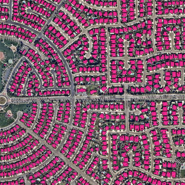
Ecopia will leverage its AI-based mapping systems to mine high-resolution multi-view aerial imagery, producing a high-precision 3D vector map of the top 100 cities. The resulting map will offer an accurate digital representation of every building, road, bridge, railway, driveway, sidewalk, parking lot, swimming pool, sports field, waterbody, forest, grassland, bare land and paved area across each city.
The cities of Thunder Bay and Windsor are consortium partners on the project and will be at the forefront of deploying these maps for sustainability-related applications. In addition, Ecopia will be offering each of the top 100 municipalities a two-year licence to the data to help support immediate action toward climate resilience initiatives.
“Canadians across the country are part of the solution in fighting the climate crisis and Ecopia is seizing the moment and doing their part,” said François-Philippe Champagne, minister of innovation, science and industry. “Our government knows that when investments in science, technology and innovation are paired with ambitious and talented Canadian entrepreneurs, it drives the breakthroughs we need to fuel a more resilient and sustainable future for everyone.”
From initial funding to educational support and peer learning to market integration, SDTC is helping small and medium-sized businesses grow into successful companies.
“Big data play a vital role in achieving and maintaining optimum environmental sustainability,” said Leah Lawrence, CEO of SDTC. “With this funding, SDTC is proud to help Ecopia optimise its data solution, paving the way for bigger market opportunities and greater sustainability.”
Ecopia is on a mission to create a digital twin of the Earth. It leverages artificial intelligence to convert high-resolution imagery into high-definition vector maps. These maps form a digital representation of reality and are embedded into decision-making applications, offering insight at scale. The maps are being used for hundreds of commercial and government applications across over one hundred countries around the world.
“We’re excited and honoured to be leading the creation of this high-precision 3D map of Canadian cities,” said Jon Lipinski, president of Ecopia AI. “This initiative will create the foundation of a digital twin for cities across the country, providing data that will help support smart, safe, sustainable communities.”